Rising above the flames: How Urban Sky’s Microballoon is transforming wildfire management

Wildfire incidents are escalating in both frequency and intensity each year, wreaking havoc on ecosystems, displacing communities, and endangering countless lives. In fact, according to a study by Nature Ecology & Evolution, the number of extreme wildfires has more than doubled over the past two decades.
The unpredictable behavior and hazardous conditions of these fires make every decision on the frontlines a matter of life and death for firefighters. Unfortunately, they often depend on costly tools that offer limited data on fire behavior and spread. This lack of critical information forces them to make complex decisions in dangerous environments, increasing the risks to their lives and those they strive to protect.
Fortunately, companies like Urban Sky—a leader in stratospheric technology—are revolutionizing firefighting efforts through advanced fire detection and monitoring solutions that provide real-time, high-resolution imaging data, enabling faster, smarter, and safer fire mitigation efforts.
We recently sat down with Dr. Riley Ried, Urban Sky’s Hot Spot program lead, to gain deeper insight into the company’s mission, explore how its signature solution—the Microballoon—is redefining stratospheric access for disaster response, and learn how the integration of mobile mesh networking funded by a recent NASA award is transforming fire suppression efforts. 
The Last Mile (TLM): Can you tell our readers a bit about Urban Sky? What solutions does the company offer, and what industries and types of users does it work with?
Dr. Riley Reid: Urban Sky is a stratospheric technology company based in Denver, Colorado, that was co-founded in 2019 by CEO, Andrew Antonio, and CTO, Jared Leidich, with a vision of making routine and easy access to the stratosphere a reality. Since then, we have redefined stratospheric access through the development of the Microballoon, and have completed nearly 300 stratospheric flights to date.
High-altitude ballooning typically involves massive balloons, prepared launch sites, and large crews of people to launch and operate. The Microballoon is a compact, cost-effective, and quickly deployable stratospheric platform capable of launching remotely from the back of a pickup truck in just a few minutes. Its versatility makes it ideal for applications such as real-time disaster response, high-resolution weather data collection, land-use imaging, and intelligence gathering.
Currently, we work with partners in the DoD, NASA, the oil and gas sector, and the commercial geospatial imaging sector.
TLM: What different use cases exist for the company’s Microballoon solution? What kinds of payloads can it carry? What can it be used to sense/identify?
Dr. Riley Reid: Microballoons operate at an optimal altitude of 40,000 to 75,000 feet, offering a superior vantage point. At this range, they provide broader coverage than lower-altitude aircraft or Unmanned Aerial Vehicles (UAVs), while avoiding the high costs and complexities associated with satellites. Additionally, they steer clear of interfering with operational firefighting support aircraft.
Urban Sky platforms are also equipped with altitude control, enabling them to shift through wind layers to ‘hover’ over target areas and achieve persistent monitoring and multi-day coverage. This broad coverage and persistent observation capability make them ideal for responding to disasters, gathering intelligence, and land-use imaging.
“HOT SPOT OFFERS UNPRECEDENTED RESOLUTION FOR ACTIVE FIRE MONITORING AND DELIVERS VALUABLE INSIGHTS INTO THE COMPLEX ECOLOGICAL IMPACTS OF WILDFIRES.” –DR. RILEY RIED
The Microballoons can support a variety of payloads, from remote sensing to communications. We currently deploy a visible imaging telescope with a nominal 11-centimeter ground sampling distance.
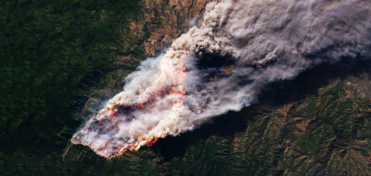
Through the NASA FireSense program (FIRET), we also deploy a thermal infrared sensor payload called Hot Spot. This advanced system features a high-resolution, 3-meter long-wave infrared sensor designed to image active fires and transmit geolocated geolocated real-time fire data. HotSpot offers unprecedented resolution for active fire monitoring and delivers valuable insights into the complex ecological impacts of wildfires.
TLM: How have government users utilized Urban Sky’s Microballoon technology so far?
Dr. Riley Reid: Urban Sky’s Microballoon has collected thousands of square kilometers of high-resolution land-use imaging for various users. We’ve also developed the ability to operate swarms of Microballoons in coordination, expanding coverage with a network of balloons.
These networks can also be used as a continuous, uninterrupted transmission network to support communications in remote areas.
TLM: In June of this year, Urban Sky was awarded a multi-million-dollar grant from NASA’s Science Mission Directorate (SMD). What will this grant be used for? What new capabilities is NASA looking to develop for the government?
Dr. Riley Reid: We are thrilled to be part of the FIRET program, which brings together experts from diverse fields to address the challenges of wildland fire management. This initiative covers a range of critical use cases, including pre-fire, post-fire, active-fire, and air quality monitoring. NASA aims to support technologies that empower fire managers to respond more quickly and effectively, focusing on solutions such as real-time, high-resolution data, advanced fire spread prediction tools, and improved communication systems to keep firefighters connected, even in remote areas.
“WE ARE ALSO EXPANDING OUR SENSOR SUITE WITH VISIBLE-TO-NEAR-INFRARED (VNIR) IMAGING… THIS ENHANCEMENT IS DESIGNED TO MONITOR BOTH PRE AND POST-FIRE ENVIRONMENTS, WITH THE FOCUS ON ASSESSING FOREST HEALTH AND DETECTING VEGITATION STRESS.” –DR. RILEY RIED
The grant was awarded in collaboration with Chapman University, NASA Jet Propulsion Laboratory, goTenna, the University of Colorado Boulder’s Cooperative Institute for Research in Environmental Sciences, and the U.S. Air Force Wildland Fire Branch to advance our real-time Hot Spot solution into an operation-ready system that can be deployed directly over active fires.
We are also expanding our sensor suite with visible-to-near-infrared (VNIR) imaging, capable of capturing ultra-high-resolution data (20 cm). This enhancement is designed to monitor both pre and post-fire environments, with a focus on assessing forest health and detecting vegetation stress.
TLM: What makes this FIRET program so important right now? What trends are we seeing that make this an essential tool for federal, state, and local government agencies?
Dr. Riley Reid: With wildfires becoming more intense and frequent, there is a pressing need for advanced detection and monitoring solutions with high data throughout. Real-time, high-frequency, high-resolution data is key—not only for early fire detection but also for devising effective fire suppression strategies.
Currently, much of our fire monitoring relies on satellites, but their resolution often falls short for early detection and many critical stages of active fire management. While aircraft can deliver accurate fire mapping, they come with significant challenges, including high costs, resource demands, and risks to the crews’ safety.
TLM: What role will mobile mesh networking play in the FIRET program? Why was it chosen to connect the FIRET Microballoons?
Dr. Riley Reid: Beyond detecting and mapping fires, our collaboration with goTenna will allow the Hot Spot system to broadcast critical information over vast areas through goTenna’s mesh network. This solution enables firefighters to stay connected, even in tough conditions off the grid.
“KNOWING WHERE THE FIRE IS AND WHERE IT WILL SPREAD IN HIGH-RISK AREAS, LIKE NEARBY COMMUNITIES, IS CRITICAL TO PRIORITIZING FIREFIGHTING RESOURCES AND SUPPRESSING WILDFIRE SPREAD AND DAMAGE.” –DR. RILEY RIED
The Hot Spot unit integrated with goTenna systems is designed to address the critical data needs in wildfire management, putting up-to-date information on fire conditions in first responders’ hands while enabling communication between teams on the ground in remote areas.
Knowing where the fire is and where it will likely spread in high-risk areas, like nearby communities, is critical to prioritizing firefighting resources and suppressing wildfire spread and damage.
TLM: Why did Urban Sky choose to work with goTenna for the FIRET program? What about the company made it the right partner for this program?
Dr. Riley Reid: We chose goTenna because they are a highly experienced mesh communication systems provider. goTenna’s systems are lightweight and reliable; ideal for operating on a compact platform and seamlessly integrating into Urban Sky’s Microballoons.
goTenna’s proven ability for long-range off-grid communications, especially for disaster response, makes it optimal for the FIRET program to confidently transmit essential fire data while enhancing firefighter connectivity.
TLM: A few months have passed since the grant was awarded. How far along is this program? What are the major milestones coming up? When will a solution be available for use on the front lines?
Dr. Riley Reid: In the first few months of the three-year program, we conducted a stratospheric flight over the active Alexander Mountain Fire in Fort Collins in early August, validating initial developments made to the system and imaging the fire in high resolution.
“BY THE END OF THE THREE-YEAR PROGRAM, OUR OBJECTIVE IS TO VALIDATE THE INTEGRATED HOT SPOT AND GOTENNA PAYLOAD THROUGH THE FIRET PROGRAM USING A SERIES OF STRATOSPHERIC FLIGHTS, ENSURING IT IS FULLY PREPARED FOR DEPLOYMENT OVER ACTIVE WILDFIRES.” –DR. RILEY RIED
Since then, we’ve focused on calibration efforts with our long-wave infrared (LWIR) system to improve on temperature and geolocation accuracy of our real-time data. We’ve also developed the first prototype of our VNIR system, allowing for the development of high-resolution forest stress and vegetation health data products.
Moving forward, we plan to continue validating these technologies in the stratosphere and are excited to begin our integration work with goTenna in the coming months. The next phases of development will focus on calibrating our data products and delivering critical fire information to fire managers.
By the end of the three-year program, our objective is to validate the integrated Hot Spot and goTenna payload through the FIRET Program using a series of stratospheric flights, ensuring it is fully prepared for deployment over active wildfires.


No Comment