
5 reasons the ATAK app should be a standard issue for mission readiness training
In a previous article on The Last Mile, Michael Thomas talked about some of the ways that the ATAK application and mobile mesh networking can help warfighters with land navigation. He also discussed how hours were shaved off of recon missions by incorporating the ATAK app and mobile mesh networking solutions into the process.
According to Michael, “Utilizing physical maps and compasses, similar recon missions could take upwards of six hours. However, with ATAK, this mission was reduced to just two.”
It’s undeniable that ATAK and mobile mesh networking can make land navigation easier and more efficient. But it can also be an effective safety device for training warfighters when it comes to MEDEVAC, airborne operations, mission planning and various other types of deployment exercises.
Here are just a few examples of how the ATAK app, paired with mesh networking off-grid connectivity can bring unparalleled accountability and efficiency to your training.
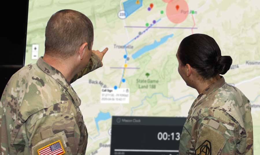
1) Mission planning & AARs
 Transmitting in an off-grid environment would involve mission planning upfront. It’s all about planning, rehearsals, and execution. This is where the ATAK app comes into play. You can actually build the mission planning data package on the Android device offline. Use the ATAK app for route planning and route reconnaissance. Leaders conducting training will be able to see trainees’ location on a map and integrate it with mission planning and mission execution.
Pre-deployment ATAK checklist:
- Download the map/dissemination of the digital plan
- Generate any required personal overlays
- Stow Android devices with loadout
- Enable command and control during mission execution
- Use your track log feature to track the mission and export it
2) Tracking soldiers for accountability and avoiding friendly fire
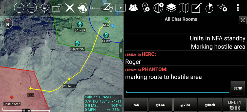 Once you pair a goTenna Pro X device and use the ATAK plugin, you’ll be able to track all training participants and provide instructions to various players throughout the exercise regardless of their role. Once you’re within range, if everyone is using the same encryption and if your devices come within range of each other, they populate location and position. Encryption can be layered to provide location obfuscation from partner forces or other units. Clearly being able to identify users in real-time helps deconflict battlespace and provide force protection. Tracking all locations allows leadership to have top-down situational awareness at all times. Tip: Hide or share blue forces at the discretion of the US personnel which is a key feature.
Another way users can leverage the tracking feature is creating a common operating picture by integrating with a TAK server. When operators are on the edge and backhauling to a TAK server, goTenna Pro X devices enable the local mesh network to populate friendly position locations through ATAK to the TAK server.
3) Set alerts and mark areas
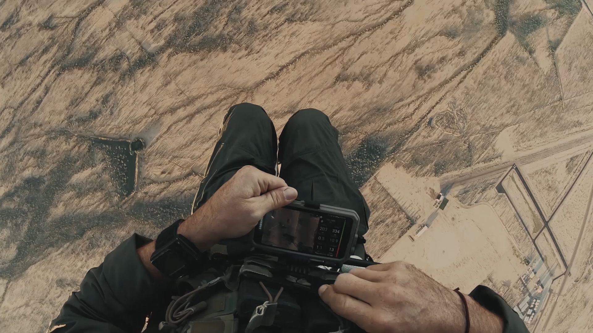
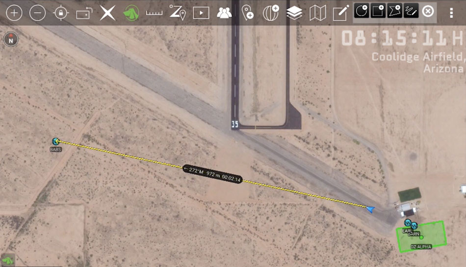 Another critical reason to be able to track participants through a map feature is to make sure no trainee goes missing or into a hazardous area. A geofence can be created to notify all selected personnel if a member enters or exits a highlighted area. Using the text feature, you can direct them back to safety if they stray too far outside of the designated training space. Take a look at how CPS Tactical Training Facility used it for tracking military freefall trainees here.
“The goTenna is actually a great solution. It’s really easy and intuitive to figure out how to use ATAK… I was really pleasantly surprised at how well it performs over distance and how it gives us real quick, real-time feedback on each other.” – Martin Rhett, Instructor, CPS Tactical Training Facility
Other map marketings could include: outlining stations, bases, observation posts, landing zones, entrances, exits as well as hostile or hazardous areas.
4) “Train like you fight” – Treat your training like you’re in combat
 Simulate an environment where all traditional forms of communication are unavailable. In a real-life scenario, a team of 4-5 soldiers might only have only one voice radio and they might have to stay within visual range to use hand and arm signals to remain operational. Using ATAK, the participants with the ability to use ATAK off the grid can spread out, cover more ground and still be able to track each other on a map and text each other within miles rather than just feet.
But what if the mission required complete radio silence and absolutely no voice comms? Paired with ATAK, goTenna Pro X can still offer a way to transmit data at a low power (With the lowest power settings set to .5W). Adjust to low power settings and use the capability of the jitter function within the application that allows for the randomization of the period of transmission for clandestine operations.
5) After Action Reviews
Logged positions throughout the mission can be used for After Action Reviews (AAR) for improving operational success. Use it as a form of command and control. Take a screen recording or take screenshots of the training session as it is unfolding. You can also use the TAK server to pull track logs or pull positions off of the diagnostic logs. It would also record network performance (e.g. how many hops were made between each device). For example, when someone falls off the network, it can show their last geo-coordinate of where they were. This can be important from a force protection standpoint as well as the team will have their last transmitting time, location, and the receiving unit’s location.
Recommendations for capturing AARs:
- Starting point: Does the starting point need to be adjusted? What are some of the challenges encountered before the exercise began?
- Notional conflict or rescue location: How fast was the conflict or challenge resolved?
- End point: Could the route be improved? Can the exit strategy be improved?
- Copy and paste pictures to a PC: Adjust your mission planning for future exercises
Don’t leave for training without the ATAK app and your mesh networking radio
Because the ATAK app is so easy to set up and goTenna gets you the network anywhere you are, use it where you might not even need it. So when it comes time to need it, you have it ready. You have the ability to use it at every mission set. Use the asset and get better at it. ATAK is used more and more in the field – so it should be an app that every soldier knows how to use.
For more information about off-grid communications for military operations CLICK HERE.

No Comment