
Elevating Connectivity: Taking Communications to the Skies with Airborne Technologies
The conflict in Ukraine has highlighted the power and recent utilization uptick of drones on the battlefield. Ukrainian forces have used small commercial drones to deter invasion attempts by the Russians. These off-the-shelf drones provide Ukrainian troops with vital intelligence, surveillance, and reconnaissance (ISR) capabilities.
The U.S. military has taken notice. The Defense Innovation Unit (DIU) recently completed the second phase of its Blue UAS program, which vets and approves commercial drones for use by the Department of Defense (DoD). The DoD cleared 17 new drone models from 11 companies for military purchase and use.
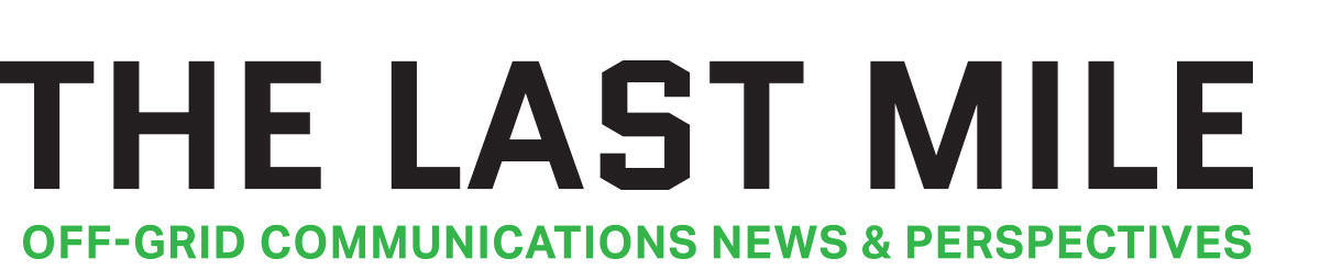
Integrating and attaching goTenna radios to drones substantially expands their operational range and utility. The aircraft’s effective coverage area will be increased by outfitting a drone with a goTenna mesh networking device. In this scenario, the drone relays communications beyond the line of sight using goTenna’s decentralized mesh network. Even if the drone goes out of range or out of line of sight from its operator, its goTenna radio can pass messages and data through other networked nodes to reach the destination. By creating this elevated relay, drone operators can maintain critical command/control links and receive telemetric data farther away.
Integrating goTenna radios into drones also enables beyond line-of-sight transmission of mission-critical data like high-resolution maps, live video feeds, sensor telemetry, and more. The increased range unlocked by goTenna’s mesh networking allows drones to safely capture and relay vital reconnaissance data from areas too risky or remote for manned aircraft. Drones equipped with HD cameras, LIDAR mapping payloads, chemical sensors, or other devices can explore hazardous terrain and send back real-time intelligence to operators miles away. The expanded coverage and enhanced situational awareness mean drone operators can access more tactical information safely from further distances while keeping manned teams out of harm’s way.
As DIU and the military look to make drones more interconnected and interoperable, goTenna is the ideal technology to integrate. Our networking protocols and encrypted mesh radios are proven to work in various environments or conditions. Using drones takes the power of goTenna and amplifies it to extend situational awareness for any team or individual using drones.
Top Drones Primed for goTenna
The drone industry keeps reaching new heights, with worldwide manufacturers pushing the limits of unmanned flight. We spotlight some of the top models on the market that are prime candidates to pair with goTenna communications. Our list includes leading consumer and public safety drones built for portability, endurance, and intelligence gathering. We cover where they excel, from autonomous flight capabilities to HD video capture, and we provide critical specs like flight times, camera details, and target applications.
While we focus on the drones’ core benefits, these unmanned aircraft also have traits that make them ideal fits for extending goTenna’s rugged, long-range mesh networking. Their capabilities complement goTenna’s strengths in areas like extended communications range and encryption. Read on to discover some of the most impressive drones out there that could take on even more challenging missions with the help of goTenna connectivity.
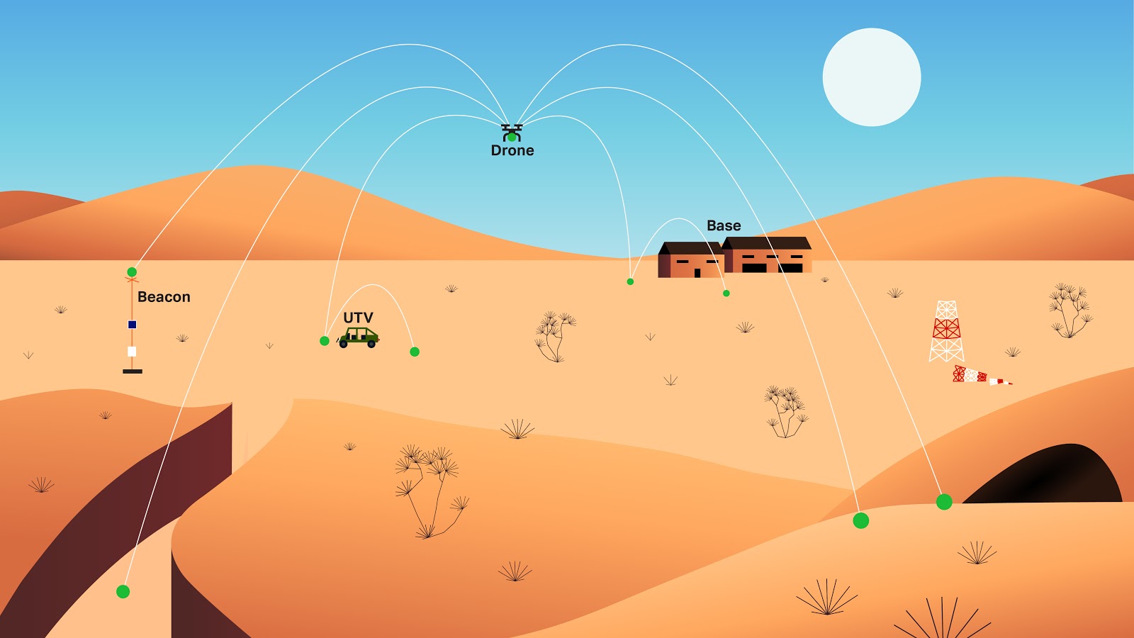
1. Darkhive Yellow Jacket
Manufacturer: Darkhive
Location: San Antonio, Texas
Model: Yellow Jacket
Features: The upcoming Yellow Jacket drone from Darkhive provides short-range tactical ISR capabilities. Its enclosed propellers and rugged carbon fiber frame enable rapid hand launch and safe retrieval.
Integrating goTenna’s mesh networking radios into the Yellow Jacket drone will amplify its potential across critical performance metrics like flight endurance, speed, and sensor-based intelligence gathering. goTenna provides reliable communications to extend the Yellow Jacket’s 15-minute flight time into wider-ranging aerial ISR missions, enabling continuous coverage of larger areas. The rapid networking supports real-time control and telemetry data exchange even at top speeds of 20 mph, allowing the Yellow Jacket to maneuver dynamically while maintaining a stable command link. goTenna enables vital sensor data like thermal imaging, 3D spatial mapping, and other telemetry to be relayed instantly over miles to ground forces instead of waiting for drone recovery. This allows the Yellow Jacket to explore hazardous spaces ahead and send alerts or critical data based on sensor readings.
The Yellow Jacket’s lightweight carbon fiber construction makes launching quickly for eyes in the sky easy. Once airborne, its sensor payload can identify and precisely geo-locate adversaries or friendly forces and share that location data through the goTenna mesh.
The Pro X’s small size enables seamless integration directly onto the drone airframe. Even at 400g total weight, the Yellow Jacket can carry the ruggedized Pro X to extend communications range beyond the line of sight.
The Yellow Jacket drone is designed primarily for defense and law enforcement applications needing portable, rapid-response aerial ISR capabilities. Its combination of small size, rugged build, sensor payload, and quick deployment from a backpack makes it ideal for frontline forces like infantry squads, SWAT teams, and special operators. The advanced imaging and tracking features also make it suitable for search and rescue missions to locate missing persons in remote areas.
Click on the link for more information about the Yellow Jacket drone.
2. Black Bar Engineering Storm
Manufacturer: Black Bar Engineering
Location: Tucson, Arizona
Model: Storm
Features: The Storm drone lives up to its name with rugged durability and high performance tailored for defense missions. Its lightweight 3D printed airframe and precision machined foam wings enable survival in combat while being man-portable. Modular payloads make the Storm adaptable across ISR, targeting, security patrols, disaster response, and other applications. EO/IR cameras, communications relays, and other sensors feed real-time data to operators on the ground. The rugged 3D-printed airframe allows the UAS to withstand combat damage and hard landings. With a top speed of 98 knots and 50 miles of range, the Storm has high performance tuned for rapidly accessing contested airspace and conducting high-altitude intelligence missions. These combined qualities make the Storm the ultimate resilient, adaptable platform ready to excel across the most demanding defense operations.
Black Bar Engineering has deep expertise in developing ISR drones specialized for military use across the Army, Navy, and Air Force. Their Storm platform is purpose-built for defense missions requiring ruggedness and advanced capabilities. Integrating goTenna’s communications radios would significantly expand the operational reach and effectiveness of the Storm. With beyond-line-of-sight control and data relay enabled by goTenna networking, the Storm could gather wider-ranging intelligence and instantly share sensor data with ground forces miles away. Black Bar’s proven track record delivering defense drones makes the Storm a prime platform to demonstrate goTenna’s capabilities for enhancing unmanned systems.
With its long endurance, modular payload options, and military-grade durability, the Storm drone is designed foremost for defense missions requiring persistent aerial ISR and strike capabilities. Modular sensor and armament options equip the Storm for surveillance and hunter-killer ops. The large airframe also supports roles like communications relay, damage assessment, and border security patrols. Government agencies like law enforcement, border patrol, and the Coast Guard could leverage the Storm’s adaptable architecture for enhanced domain awareness missions.
Click on the link for more information about the Storm drone.
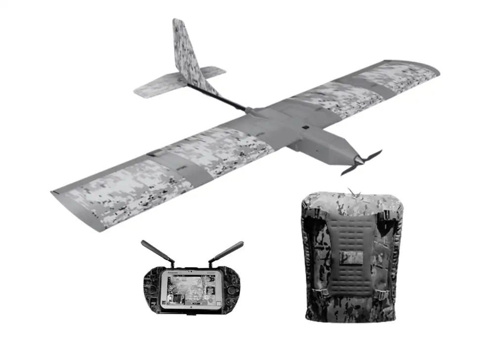
3. AeroVironment RAVEN® B RQ-11
Manufacturer: AeroVironment
Location: Arlington, Virginia
Model: RAVEN® B RQ-11
Features: The Raven RQ-11 is AeroVironment’s ultraportable drone tailored for low-altitude ISR. Weighing just 4.2 lbs, it fits in a backpack for rapid field deployment. The Raven’s 4.5 ft wingspan and 75+ minute flight endurance provide extended monitoring from low altitudes up to 15,000 ft. Equipped with a stabilized gimbaled payload, the Raven delivers real-time color/IR video and imagery to ground control stations within 10 km. The advanced avionics allow for either manual or pre-programmed GPS navigation.
With its lightweight and compact size, the Raven RQ-11 is an ideal drone platform for integrating goTenna’s communications technology. At just 4.2 lbs, the Raven can easily carry goTenna’s small mesh networking radios to extend data and control reach without compromising flight endurance. The low-altitude ISR missions the Raven excels at are perfect for leveraging goTenna’s terrain-hugging mesh networking capabilities. Equipped with goTenna, the Raven can relay surveillance data and telemetry beyond the line of sight to ground forces far outside its standard radio range.
The ultraportable Raven has been adopted widely across defense sectors needing rapidly deployable ISR. All branches of the U.S. Armed Forces utilize Ravens for situational awareness and reconnaissance during combat operations. Coalition partners, including the UK, France, and the Netherlands, have also deployed the Raven for light infantry support. With over 20,000 fielded, the RQ-11 has become an integral air asset for frontline surveillance and intelligence gathering across air, land, and sea domains.
Click on the link for more information about the Raven drone.
Expanding Mission Potential with goTenna Integrated with Drones
Rapid Network Extension:
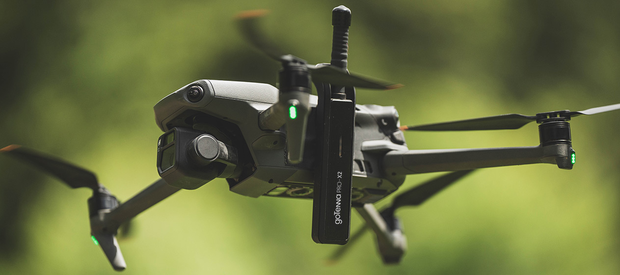
In addition to outfitting drones for long-range flights, there are creative ways to utilize drone mobility to extend goTenna’s mesh network coverage. For example, an operator could perform periodic quick drone pop-up flights to relay signals beyond the line of sight obstructions temporarily. The drone would provide a mobile aerial node to route mesh traffic before landing at its home base. Alternatively, drones could be flown to optimal high-altitude “perch” positions and put into standby mode while keeping their goTenna radios active. The airborne drone would then act as a networked relay for ground nodes, enabling communications through and around challenging terrain. Whether through brief sorties or hovering in place as communications hubs, drone mobility adds a vertical dimension to goTenna meshing that can stretch far beyond what ground-based nodes could achieve alone.
Enhanced ISR Gathering:
Drones outfitted with goTenna are incredibly well-suited for intelligence, surveillance, and reconnaissance (ISR) missions. A drone equipped with high-resolution cameras, thermal sensors, or other payloads can provide critical aerial reconnaissance deep in enemy territory or hazardous areas. If the drone spots something of tactical importance, it can immediately send alerts and imagery back to operators using goTenna’s encrypted mesh network. The discovery can be quickly communicated beyond the horizon rather than returning the drone to the line of sight range.
Real-Time Sensor Data:
Drones equipped with goTenna radios can provide tremendous utility for collecting and transmitting environmental telemetry and sensor data. By mounting air quality sensors, anemometers, thermometers, or other payloads to drones, operators can gather vital atmospheric measurements from altitude. As the drones conduct sampling missions in the sky, the sensor readings can be relayed in real-time to ground stations miles away using goTenna’s mesh network. Rather than waiting for the drone to return, critical wind speed, temperature gradient, or pollution data can be immediately accessed by personnel on the ground. If hazardous conditions are detected, timely alerts can be disseminated. The expanded transmission range enables new possibilities for drones to safely explore hazardous airspaces and provide continuous environmental intelligence beyond the line of sight.
Dynamic Wildfire Tracking:
Drones outfitted with goTenna mesh radios could be critical for tracking raging wildfires. Equipped with infrared cameras and other sensors, the drones could be deployed to overfly massive blazes and autonomously map their boundaries. As the flames spread and the fire perimeter shifts, the drone fleet could provide continuous real-time mapping data to personnel on the ground. Firefighters would instantly gain an accurate picture of where the fire lines stand and which areas are still threatened, even if the drones are miles beyond the line of sight. This would allow fire crews to deploy resources with precision and evacuate people in harm’s way, armed with up-to-the-minute intelligence no matter how remote the location.
goTenna and Drones Teaming Up
By harnessing drone capabilities with goTenna’s resilient communications, new possibilities emerge across missions from ISR to emergency response. As unmanned systems take on more significant roles, innovative integration of technologies like goTenna will be essential. We look forward to teaming with leading manufacturers to demonstrate these benefits in the air. With expanded range and connectivity, drones can reach their full potential in areas too risky or remote for manned flights. The sky’s the limit when goTenna takes tactical communications to new heights.
Disclaimer: Please note, for all aerial assets, be sure to follow any applicable government regulations and restrictions during your deployment.

No Comment