
How sensor networks and mobile mesh networking are countering the UAS threat
Drones have become pervasive in our culture and society. YouTube is filled with amazing aerial drone footage of natural wonders. Young children are gifted small drones as holiday presents. There are event mall kiosks that sell small drones. Consumer drones are everything from a neat hobby for some to a cool toy for others. They’re even used professionally to assess the damage to homes after hurricanes and structural conditions when renovating structures.
But while the average American might have grown accustomed to drones and think of them as a fun novelty, they’re a real problem for many government and military organizations.
In the government and military, consumer drones are called unmanned aerial systems (UAS), and they can be used to create havoc by both the ignorant or the intentionally malicious alike.
The ignorant can sometimes unintentionally fly a UAS in a location that is a sensitive or dangerous area. The operation of a UAS near a military base or near a small airport could have massive homeland security or safety considerations. Accidental imagery or videos from military installations uploaded for the world to see on the Internet is a military nightmare. And if a bird strike was capable of causing the Miracle on the Hudson, it goes without saying that a drone strike on an airplane could have downright tragic consequences.
Those are just the unintended consequences of ignorant UAS operators. An entirely different group is intentionally using advanced consumer UAS platforms to circumnavigate our country’s laws and even carry out attacks on deployed warfighters.
There have been documented cases of ISIS and other terrorist organizations carrying out bomb attacks using consumer UAS platforms. There is genuine concern within the military and the defense industrial base (DIB) that UAS platforms could be modified and weaponized to carry chemical, biological, or other weapons payloads.
On the U.S. southern border, consumer UAS platforms are doing the dirty work for drug cartels. There have been numerous reported cases of consumer drones carrying tens of pounds of heroin and other drugs over the U.S. / Mexico border and into the waiting hands of associates in states like California. In these instances, the drones are less like those bought on Amazon and at mall kiosks as children’s toys, but more like the giant, sophisticated, and costly devices used on movie sets and to cover professional sporting events.
The use of drones like these for drug smuggling has become so common that it lead Air and Space Magazine to write an article with the headline, “How Many Drones Are Smuggling Drugs Across the U.S. Southern Border? Answer: Nobody knows.” They’re so common that one fell out of the sky and crashed into a grocery store parking lot in Tijuana carrying 18lbs of meth, causing a real problem for U.S. Customs and Border Protection.
With consumer and advanced UAS platforms creating concerns and problems for many government and military agencies, it would seem like just a matter of time before these organizations caught on and started neutralizing errant and malicious drones en masse. Unfortunately, it’s not that easy.

Finding a needle in a pile of needles
A small, consumer UAS is inherently difficult to see or notice – especially from the ground when it’s at altitude. This means that noticing and reacting to a drone quickly is less like finding a needle in a haystack, and more like finding a particular needle in a pile of needles.
Because they’re so small and difficult to detect in the sky, a drone piloted by a malicious actor may be at or near its desired location before authorities or military personnel are aware of it. That also means a UAS could be piloted into an area that creates an unsafe situation by ignorant operators before anyone notices it.
Let’s say a UAS is making its way towards a military base, airport, or border crossing. How can the government or military personnel be so sure that it’s about to intentionally or unintentionally be used for something nefarious, risky, or dangerous? It’s nearly impossible to discern why and where a drone will go by simply observing it from the sky. It’s also definitely impossible to establish the intent of the UAS operator.
Should a drone be operating near or flirting with restricted air space around a military base or airport, should local law enforcement or military personnel shoot it down? Should they pursue the operator and attempt to arrest them? What happens if that UAS was never going to enter restricted air space? What if a child’s special present from Santa was left in a broken heap in the middle of the woods?
That example may seem extreme, but it’s possible. And it’s not what anyone wants in that situation. But what can be done about it?
More sensors, more connectivity, more insight
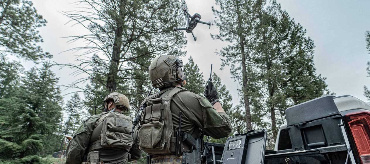
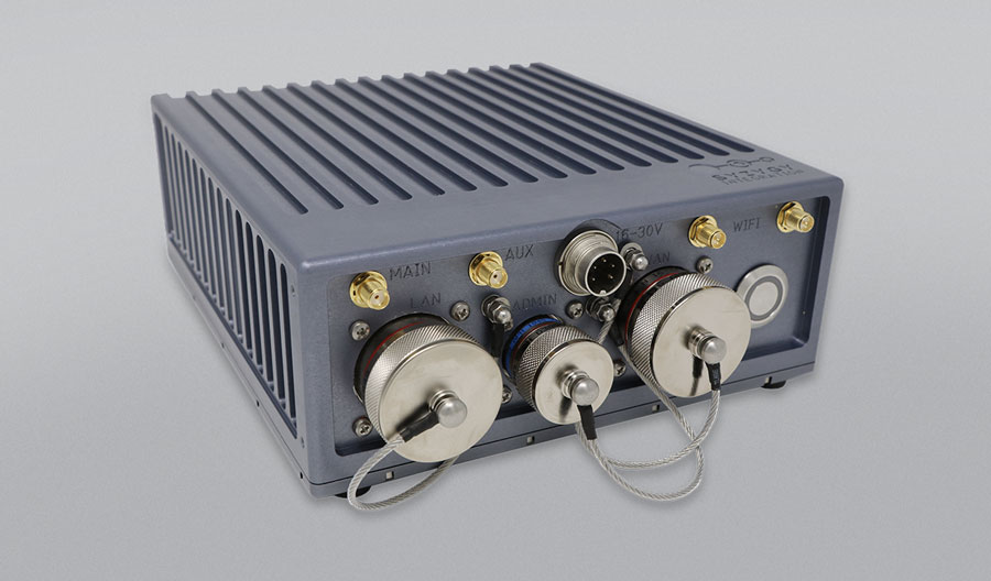
Syzygy has found that trying to identify a UAS and the intent of the UAS operator for counter UAS (CUAS) operations is nearly impossible when the amount of data available about the situation and potential threat is limited. Syzygy has worked to integrate its Sensor Network Access Point (SNAP) system with multiple CUAS sensor and communication systems. Syzygy has enabled these sensors to be controlled/monitored from anywhere in the world with a fully integrated single situational awareness picture of disparate sensors. Today, SNAP is used all over the country to integrate sensors and communications – such as goTenna’s Pro X – to help solve this problem.
Utilizing numerous, integrated, and connected sensors across a geographic region, law enforcement, and military personnel can better understand the threat that a UAS may pose and even identify if there is clear intent to use that UAS maliciously. However, connecting these numerous sensors can be challenging in some locations and expensive in others – making mobile mesh networking a desirable solution for joining them together.
In geographically remote locations – places like along the southern border where a UAS could be used to smuggle drugs – terrestrial networks don’t exist, and satellite networks can be prohibitively expensive. In locations like these, Syzygy has used mobile mesh networking devices – like the goTenna Pro X – to connect the sensors and then utilized a single satellite connection to make it possible to monitor and analyze the data that they generate remotely. This eliminates the high cost of having multiple, expensive satellite terminals and antennas and limits satellite throughput requirements, making the solution less expensive and more scalable for users with tight budgets.
In urban environments and other locations where cellular networks are available, a similar setup can be used with cellular connectivity to deliver cost savings to the end-user. By limiting the number of sensors utilizing cellular connectivity, government users can roll out and scale up CUAS sensor networks at a lower cost.
Finally, mobile mesh opens the door to provide direct, real-time data distribution to law enforcement and military personnel in the area of operations. Instead of the data being transmitted via satellite or cellular network, only to be displayed on the mobile device or ruggedized laptop of tactical operators, mobile mesh networking can push the data to them directly – expediting data delivery and enabling them to see UAS activity in near real-time.
The drone that you buy your child for the holidays or see at a mall kiosk is most likely harmless in the hands of the average American. But not everyone uses a UAS for sweeping aerial nature photography or scouting out the damage to oceanfront properties after a hurricane. Some malicious actors see a consumer drone, and they see a weapon. Or they see a means to smuggle drugs across our borders.
Identifying the good drones from those bad ones isn’t easy. And that can make protecting Americans and warfighters against UAS platforms that are being used for malicious purposes pose challenges to our government, law enforcement, and military. Today’s advanced, connected, and integrated sensors and sensor networks can help identify these UAS platforms before they cause problems. Mobile mesh networking can make connecting these sensor networks more reasonable, cost-effective, and scalable for our government.
To learn more about Syzygy, click HERE. To see how you can integrate mobile mesh networking into your communications systems, download the goTenna Pro Embedded Module PDF HERE.


No Comment