

Hot Take: GPS trackers versus goTenna Pro X and mobile mesh networks
As part of the Hot Takes series, we’ll be taking a highly debated topic and exploring the pros and cons of both sides. During each debate, you’ll hear from goTenna Pro experts who offer the hands-on experience from working with customers and deploying goTenna Pro X devices in the field. Cast your vote, leave a comment below, or sign up for a future debate!

Knowing the exact GPS location of your teammates is essential for situational awareness. In wildland firefighting, the ability to track the location of every individual team member and the fire is often referred to as “The Holy Grail.” But now, the combination of new technology and recent legislation could make this long-awaited vision a reality.
So, which technology is best suited for the job?
The Last Mile recently asked goTenna team members – Brian Ellis and Luke Stewart – to share their take on two leading solutions, goTenna Pro X mesh networking devices and GPS trackers.
Brian retired from 20 years of military service, 15 of which were as a Green Beret in the US Army Special Forces as both a Special Forces Engineer and Special Forces Intelligence Sergeant. HE has extensive experience deploying mesh networks in the field.
Luke has hands-on experience as a former firefighter, police dispatcher, and soldier in the U.S Army. In his previous posts on The Last Mile, Luke Stewart has covered why firefighters should look to UAVs when it comes to the future of fighting wildland fires and why radios sometimes fall short when battling a wildfire.

I will start out by saying comparing a goTenna Pro X mesh networking radio device to a satellite subscription-based GPS tracking system isn’t exactly an apples-to-apples comparison.
But, both tools are a potential solution to a common challenge: situational awareness down to the individual operator.
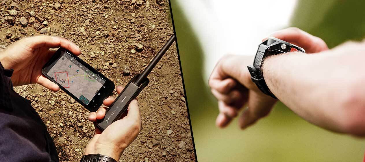
Many wildland fire crews and other teams have turned to ruggedized smartphones and mobile apps in order to provide location tracking, mapping, and other communications capabilities in the palm of every team member’s hand.
If you can use a cellphone, download apps, and read a real-time map displaying points of interest, as a first responder, you can instantly know where your team is, the best navigation routes, and have a back-up form of communications when other forms fail.
When fighting a fire, losing communications is a major problem. When a GPS user goes “dark” and no longer sends out a location, you have to assume the worst has happened. The mission then becomes about recovery and rescue of personnel instead of fighting the fire. No one wants to lose personnel. Everyone wants to put out the fire, rescue a stranded individual, and save lives in order to complete the mission.
Having the most certain and easiest methods of understanding the situation is key. Some obvious advantages that a mobile mesh network provides is the capability of an ever-expanding network that can be implemented when cell towers and line of sight are compromised. The ability to breadcrumb goTenna Pro devices X devices gives responders the connectivity to track personnel and communicate as conditions change, in real-time, and over a large area.
Should all other forms of connectivity in the field fail, goTenna Pro X was designed to keep functioning completely off the grid. It’s a redundant communications and navigation tool that can become the primary means of keeping contact. Responders can see the location of personnel within a three-foot radius of accuracy. goTenna Pro X’s battery lasts longer than most cell phones. The battery life can be extended with portable battery chargers, and can charge while being used. The device requires that responders have a smartphone and downloaded the app prior to deployment. Both the phone and goTenna Pro X can be ruggedized to withstand tough conditions.
Usability is proving a non-factor. With less than an hour of training, users take full advantage without error or complications. The situational awareness features like the map and personnel tracking are also paired with a securable network for text messaging off-the-grid. You can pair the goTenna Pro X with third-party apps like ATAK to enable off-grid communications.
All of these added features do come with a price. Extra weight for a firefighter, especially wildland firefighters who strip their gear packs to basic essentials, is a factor. With personnel already carrying radios, tools, and protective gear, it could be tough to add a ruggedized phone and a goTenna Pro X (even though the mesh networking device weighs less than 3 oz).
Financial costs are another limitation. First, responders would need to carry a smartphone. While most already likely own one, it needs to be factored into the overall cost. Keep in mind that the goTenna Pro X is 4-5 times the cost of basic GPS trackers because of it’s messaging, map-marking and other situational awareness capabilities.
In highly secure conscious environments, you would need to toggle the encryption mode to “on” and operate independently of cell networks. To communicate via text or to send location data location would produce a small data packet that is not easily noticed. But, the risk should be noted.
To sum it up, if conditions allow and funding allow, added weight is manageable, and encryption is enabled, a mesh network can provide a set of features that allow the best possible situational awareness for first responders.

A GPS tracker gives as accurate a depiction of location as is possible. I can determine my exact GPS coordinates, communicate them via the radio, which I am required to already be carrying, and everyone on the team can be apprised of locations. It used to be that a responder would need to use a paper map to determine location, then radio that to the others who were doing the same. That’s a situation with a large capacity for error.
Now, all the individual coordinates can be entered into a computer and placed accurately on the map for precise situational awareness.
From a usability standpoint, GPS trackers require almost no learning curve. Apart from the lightweight and cost-effective unit (less than $100/unit), an accurate span of control can be maintained.
A radio battery typically lasts for 36 hours. A GPS unit’s battery will outlast most cell phone batteries. GPS trackers are typically small in size, easily protected, and don’t add much burden to the responder’s pack.
In regard to security, GPS trackers do not reach out for other services across a network. They cannot be picked up by an adversary’s radar, since they don’t communicate back to the satellite. A spectrum analyzer cannot detect the GPS units alone. One potential security risk that should be mentioned is that in order to communicate GPS coordinates, a responder typically keys up a radio, which is detectable by analyzers and presents a larger data packet on a standard frequency.
One other issue that responders encounter using the combination of GPS trackers and handheld radios is that communicating a full team’s coordinates is time-consuming. Each member needs to take their turn occupying the frequency. While this is happening all other communications, which are sometimes quite urgent, are on hold as the team tries to ensure situational awareness.
First responders often experience the noise of one user talking over another on handheld radios. It can be a bit messy and has an inherent possibility for error due to this noise – especially if multiple agencies are responding to the same scenario and operating on the same frequency.
GPS trackers can provide reliable and necessary situational awareness at lower cost than mobile mesh network solutions. They offer a low-cost redundant communications solution with ample battery time, less gear and training required.


No Comment