
How Tough Stump’s ATOS solution is enhancing ATAK’s GPS tracking capabilities for the warfighter

When the Android Tactical Assault Kit (ATAK) was released a decade ago, its situational awareness and communications capabilities completely transformed how military, law enforcement, and emergency response teams coordinate and communicate during their missions. For more than 10 years, ATAK has been enabling any warfighter with an Android device to utilize such capabilities as pin dropping, perimeter drawing, and map routing, and other useful solutions that increase collaboration, situational awareness, and mission success.
Having situational awareness including all individuals, vehicles, tools, etc. is of the utmost critical importance during a mission. However, when warfighters and emergency responders are in heated, high-pressure, and dangerous environments, it can be nearly impossible to keep tabs on the locations of mission-pertinent assets. Thankfully, Tough Stump has developed a solution to these tracking challenges.
Tough Stump, a Service Disabled Veteran-Owned Small Business (SDVOSB) that provides technology integration for the military, has taken ATAK’s functionality to new levels with the development and release of its Android Tactical Object Surveillance (ATOS) solution. ATOS, a GPS tracking solution, further enhances the situational awareness capabilities of ATAK for warfighters and emergency responders in the field.
The Last Mile had a chance to sit down with Tough Stump’s Co-Founder and CEO, Jarrett Heavenston, Specialized Training Program Manager, James “Jimbo” Michael, and Lead Software Engineer, Mike Smetana, to discuss the tracking challenges that warfighters and emergency responders are currently facing, demonstrate how ATOS is eliminating these issues in conjunction with mesh networking, as well as share the incredibly moving backstory behind ATOS’ name.
Here is what they had to say:
The Last Mile (TLM): What is ATOS? What capabilities does it give to the military and emergency response crews?
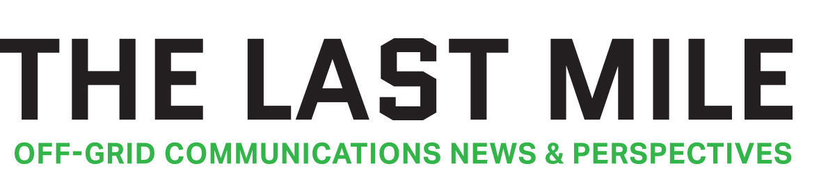
James “Jimbo” Michael: ATOS is a GPS tracking device that is intertwined into ATAK. It can be used by emergency response and military organizations to track the physical locations of individuals, assets, vehicles and other things in the field on a map in ATAK.
This gives users better, more accurate situational awareness, and also keeps them from losing things in chaotic situations and scenarios.
Basically, ATOS tags receive GPS location from satellites, and the tag talks to a command link over 432 – 436 Mhz, which is connected by BLE or hardwire USB-C to the end-user device – phone, tablet, laptop- where it is imported into ATAK. Right now, the user receives a report on each tag every two seconds. With a two-second refresh rate, users can track the locations of up to 100 of these tags in ATAK at once.
TLM: How big of a problem is the tracking of military and emergency response assets in the field? Can tactical operators really lose things like vehicles and other assets?
James “Jimbo” Michael: Being in the military and on the ground for hundreds of active missions overseas, you lose track of things– working dogs, vehicles, assets – all of the time. You could be in elephant grass that is six feet tall, and you can be looking for people and not find them. You can have people or working dogs go into a building and not know they entered those buildings.
It seems silly to say that warfighters and first responders lose things, but the situation that they’re in is high-stress. There are many different individuals involved, and it’s far easier than one might think to simply lose track of things.
But it’s not just about losing things. There are other reasons why we may want to know the exact location of assets.
Being a joint terminal air controller for 25 years, I had to call in airstrikes. When I was on the ground, I would have to track where everyone was in addition to all of our assets. I was doing that with voice coordinates and paper. Now, with ATOS, every person and asset can have a tag and I can see where they are in real time.
In many emergency response scenarios – there can be various agencies responding to one event, and they don’t always cross-communicate or talk. Now, with ATOS combined with ATAK and a responder’s mobile device, you can give everyone a tag and enable a common operating picture for all responding agencies.
Mike Smetana: We have a lot of experience in unmanned aircraft systems (UAS) operation. And one of the original purposes of the ATOS kit was to track our ARTEMIS drone that collects imagery and digital surface models of various terrain. In the event that the expensive UAS platform goes down, we want to know where it is so we can attempt to recover it.
We’ve also been exploring applications in the airdrop bundle community. We do a lot with drop zones and assault zones, both from the pilot and airplane perspective, as well as the ground surveyor. Being able to accurately determine the location of an airdrop bundle is definitely a mission-critical capability that we’re hoping to achieve with the system.
TLM: Where did ATOS get its name?
Jarrett “Fish” Heavenston: When we started Tough Stump, our first product was an aerial mapping solution that we call ARTEMIS. We were using a GPS tagging and tracking system to track the location of the drone, because we knew we would be sending it out further than we could communicate with it.
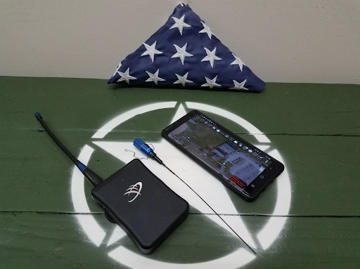
A few months later we were out in Bend, Oregon, training a customer on ARTEMIS and I started thinking about ways that we could expand the use cases of this GPS tracking system. I was inspired by an event that happened in Iraq on Christmas Eve, 2007 with a Military Working Dog named “Atos.”
I was part of a special forces task force that intercepted an enemy combatant in their vehicle. The bad guys had run into very dense underbrush alongside a riverbank. As hard as I tried to eliminate our target with Close Air Support, all attempts failed, and we had to pursue them by foot.
I was a Combat Controller, talking with the overhead surveillance aircraft, which were trying to provide us vectors to the last known enemy location. I was upfront with the dog handler, Sam, taking the verbal instructions from the radio, and then relaying them to Sam, who was casting out Atos in the direction provided.
It was dark. The underbrush was dense. We were closing in on an adversary with the upper hand, who was lying in wait for us and potentially wearing a suicide vest. As we were closing the distance on the enemy combatant, we got a call on the radio that the dog, Atos, had located the adversary.
But, trying to find the adversary and Atos was almost impossible. The dog was on him, but in the thick underbrush. We couldn’t find the dog. We finally converged on the enemy location, and thats when he emptied his pistol into Sam then detonated his suicide vest.
Atos was killed immediately, and four of our soldiers were grievously injured on that Christmas Eve. There are a lot of battles that I’ve forgotten about, but that’s a moment that will always stick with me.
Reflecting on it years later, in Bend, I couldn’t help but think that something like these GPS trackers could have made a difference. If we were able to know where the adversary was, we would have been able to pull the dog back and eliminate the adversary in a way that wouldn’t have resulted in the death of an incredible working dog, and the injury to multiple soldiers.
TLM: Many of our tactical operators – whether they’re military or first responders – have to operate in austere environments where cellular networks and signals may not be available. Can ATOS be used in these environments? How?
Mike Smetana: The ATOS software and hardware were designed as a standalone solution. You can track 100 tags without the need for additional radios, cellular, or satellite infrastructure. The software can manage all of that locally, so there is no need for edge computing or the tactical cloud. The ATOS information can go as far as your tactical network, one of those obviously being goTenna Pro X, which we love.
James “Jimbo” Michael: We can use mobile mesh networking in connection with ATOS, enabling us to operate even when there are no terrestrial networks.
We’ve used goTenna Pro X backbones in collaboration with ATOS to track vehicles, personnel, objects and parachute bundles in the water and air. Water drop zones are difficult, because anything dropped into the water will move. By placing an ATOS tag on the buoy where the drop was supposed to occur, we were able to extend our network by using goTenna Pro X’s on the plane and boats. This enabled all players to see where each other was located as well as where to drop the bundles and help recover the bundles.
In a similar situation, we were dropping bundles, and were able to achieve a strike report where the bundles landed within 200 meters of the desired impact point. When you have divers going to find those bundles, this makes it much easier for them to locate the packages.
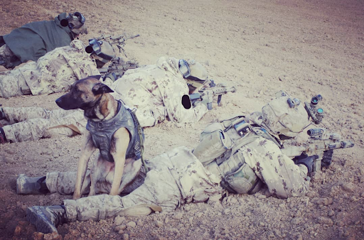
In another example, we were training search and rescue personnel in a snowy environment, off-the-grid. We once again used goTenna Pro X mobile mesh for our backbone and ran training scenarios where people had to find lost or down individuals. We buried the tags under five feet of snow and received updates over the span of many hours from 2000 meters away.
We’ve also put ATOS tags on Military Free Fall jumpers. Last September, one of our tags fell out of a jumper’s pocket from 12,000 feet up in the air and continued to transmit after it hit the ground. We simply were able to walk straight up to the tag and recover it.
Why was that significant? If you have a tag on a jumper who has a malfunction, they may land far from the DZ and be incapacitated. The quicker you get to him, the higher the chances of getting him stabilized and into a medical facility, which increases the chances that he is going to survive.
TLM: What is necessary to begin tracking things like K-9 units, vehicles, and other assets in the field? What does the military have to buy to use this solution off-grid? Is it a lot of extra gear to carry? A large expense?
James “Jimbo” Michael: Basically, you need three things to begin tracking: an ATOS tag, a Command Link and an ATAK enabled device. The Command Link is about the size of a deck of cards and receives the location data from all of the tags. The tags run off of a 123 battery, which will provide 48 to 50 hours of functionality, and we have a functional range of four miles on the ground.
Airborne to ground operations, the command link constantly picks tags up from a distance of 25 KM away – and that’s radius – so a diameter of 50 KM. The tag is so small that it can go in a shoulder pocket and the operator probably won’t even know it’s there. It’s about the size of your thumb.
Since the military is already running ATAK, they don’t necessarily need new end-user devices – smartphones or tablets – but those are also necessary. In order to share ATOS data with other team members off-grid, you would need mobile mesh networking equipment, such as the goTenna Pro X.
Together, the addition of ATOS and a goTenna Pro X adds very little weight to the tactical operator, and the entire solution can be rolled out across an entire group of operators at a very low cost.

No Comment